Derwent and Howden Dams in Winter

This is Howden Dam in Derbyshire. Yesterday the sun shone and it was a glorious day for walking. We walked around Derwent and Howden Dams which [according to a leaflet I have] is eleven and a half miles long. We did it in just over four hours so I don't really believe it can be as far as that.
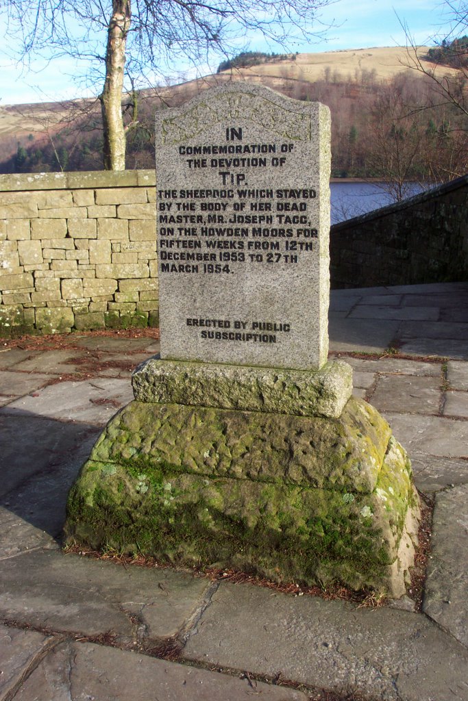
After parking at Fairholmes and paying the £3 parking fee [I really must get a season ticket] we walked beside Derwent Dam initially. Here we saw the memorial to The Dambusters [see http://www.dambusters.org.uk/dermus.htm ] as well as the memorial to Tip [also pictured].
After that the walk didn't feature anything of great import until we got up to Slippery Stones where we crossed the old packhorse bridge which had been moved from further down the valley and rebuilt by public subscription 100 years or so ago. That isn't quite true of course because by the time we'd got to Slippery Stones we'd already walked through all that remains of Tin Town [or Birchinlee as it was properly known]. Here at the beginning of the 20th century, the navvies were housed and with their families there were 910 people at one time. This little village had a grocery store, and all the facilities that the navvies needed. All that remains are a few flat earth platforms and the odd wall here and there.
After Slippery Stones we walked down the other side of both Howden and Derwent Dams enjoying the sun and being thankful that we'd walked it this way round as we would have been in the shade otherwise.
There were plenty of walkers out [and just as many cyclists. Most of whom didn't say 'Hello' or 'Hi' like most walkers do to each other]. Two cyclists had bells and used them - the rest didn't. Perhaps someone could tell me why cyclists don't have mudguards now ? They'd all got muck and mud up their backsides ....
3 comments:
A facinating area, with interesting historic connections, although the role of these damns for the Damnbuster mission is often overstated. The Derwent Damn was one of many used by the crews when training. The Derwent Damn was used by the crews who attacked the Sorpe Damn, which was not breached during the raid. The main significance of the Derwent Damn was that Guy Gibson (the raid leader) flew over it twice; once to test whether he could fly over a reservoir at low level at night and on another occasion to test the wooden bomb sight that was developed for the raid. This sight, when lined up with the towers, indicated the correct distance for bomb release. Nevertheless, a Lancaster flying over the Damn is wonderfully evocative sight.
I think one of the other great sights of the valley is when the overflow from the Derwent Damn is frozen.
BTW, mountain bikers avoid mudguards as the mud jams between the wheel and the tyre. Of course most mountain bikes are never used on mud and hence could have mudguards fitted, but then they would not look so "cool".
G
It probably is that far but, being relatively flat on good paths, you will have made good time.
Thanks for this G - it made interesting reading. I can imagine the overflows being worth a closer look when frozen. We got right down to the Howden overflow but all three photos were either under- or over exposed. I should have taken more time and tried different exposures but was feeling too tired by that time.
As regards mudguard I wondered whether it might have come down to street cred .... this is the reason bells aren't popular I believe.
I still haven't measured the distance but will do so and report back. As you say there isn't much uphill and downhill 'work' but even so we would have been going at a fair pace to do eleven and a half miles in 4 hours.
What a great resource!
Post a Comment